
Ireland is currently facing a significant meteorological challenge as a series of heavy rain bands, driven by a persistent low-pressure system, continue to batter the country. National forecaster Met Éireann has upgraded and extended several weather warnings, placing a primary focus on the East and Southeast, where the combination of saturated ground, high river levels, and spring tides has created a “perfect storm” for flooding.
The Current Warning Status
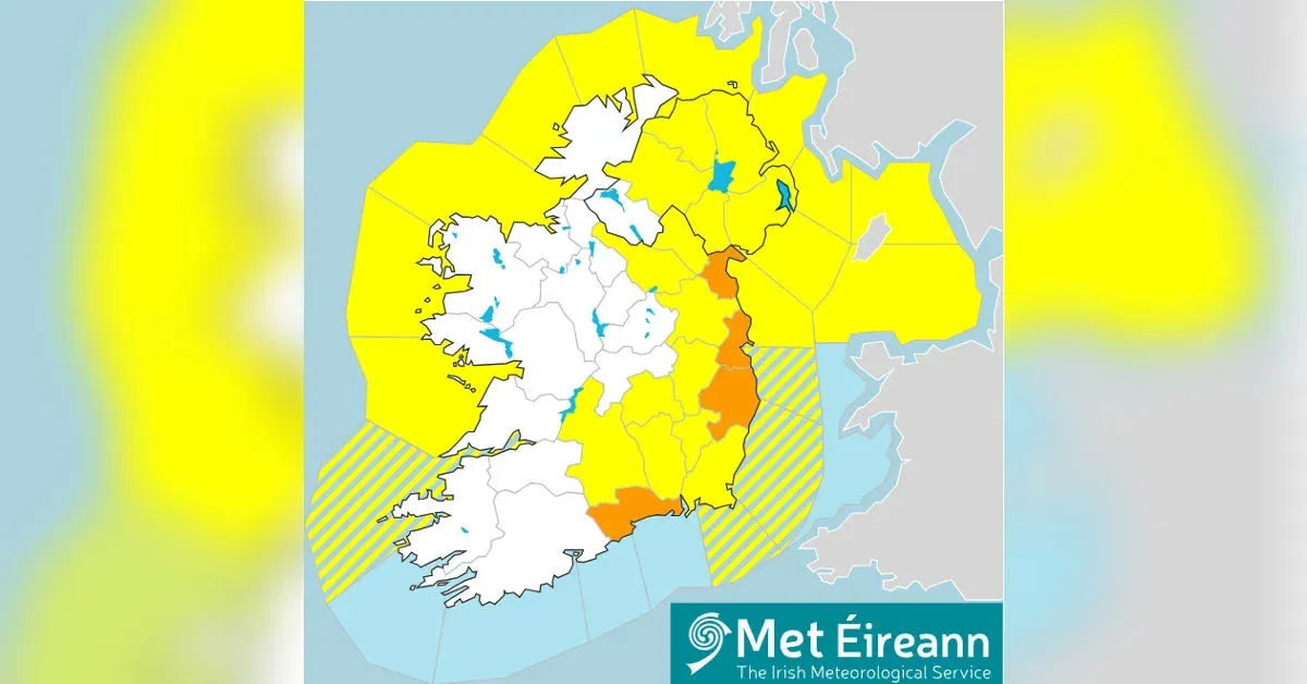
The most severe alerts—Status Orange Rain Warnings—are currently in effect for Dublin, Wicklow, Louth, and Waterford. These warnings signify a high risk of “acute flooding” and dangerous travelling conditions. While originally set to expire earlier, the Dublin alert has been extended until 3:00 PM on Friday, February 6th. Residents in these areas are being warned to prepare for river and surface flooding that could impact homes and businesses.
In addition to the Orange alerts, a Status Yellow Rain Warning covers a vast portion of the country, including Carlow, Kildare, Kilkenny, Laois, Wexford, Tipperary, Cavan, Monaghan, and Meath. In Northern Ireland, the Met Office has issued similar Yellow warnings for Antrim, Armagh, Down, Tyrone, and Derry.
The Science Behind the Surge
Meteorologists explain that the current crisis is not just about the amount of rain falling today, but the condition of the land itself. After weeks of unsettled weather, the soil across Ireland is “saturated” or “waterlogged,” meaning it can no longer absorb any more water. Consequently, every millimetre of new rainfall runs directly into already swollen rivers like the Slaney, the Liffey, and the Boyne.
Compounding this is a period of High Spring Tides. On Thursday afternoon, coastal communities saw water levels rise significantly. When strong easterly winds (reaching gale force 8) push the sea toward the land, it creates a “surge” that prevents rivers from flowing into the sea. This “backing up” effect is what causes many urban areas to flood even if they are not directly on the coast.
Travel and Safety Disruptions
The impact on daily life has been immediate. Dublin Airport has reported several flight cancellations and delays due to visibility and wind. Rail services, particularly on the Dublin-to-Rosslare line, are being monitored closely, with some sections already experiencing “speed restrictions” due to water on the tracks.
Local councils have been proactive. In Dublin, coastal car parks in Clontarf and Sandymount have been closed to the public to prevent cars from being trapped by wave overtopping. Fingal County Council has deployed thousands of sandbags to known “hotspots” and has urged the public to stay away from riverbanks and sea walls.
Emergency Advice
The Irish Coast Guard has issued a simple but vital reminder: “Stay Back, Stay High, Stay Dry.” Walking near swollen rivers or piers during high tide is extremely dangerous as “rogue waves” can easily sweep a person into the water. Additionally, ESB Networks has warned the public to stay away from fallen power lines, which should be treated as “live” and reported immediately.
The unsettled weather is expected to last until at least February 9th, with further rain forecasted for early next week.


