
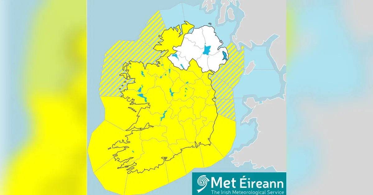
Ireland is currently navigating a complex and dangerous weather “compound event.” While Met Éireann has maintained a Status Yellow warning for rain and ice, the reality on the ground is much more severe. Emergency management teams are warning that the classification of the rain is less important than the state of the landscape, which is now at a breaking point.
The Saturated Ground Phenomenon
The defining feature of this week’s weather is “soil saturation.” After an exceptionally wet start to February, the Irish landscape is effectively a “full sponge.” Usually, the earth can absorb significant rainfall, but current Soil Moisture Deficits are at zero across the country. This means that every millimetre of rain falling today in counties like Cork, Kerry, and Waterford is not soaking into the ground; instead, it is running directly into already swollen river systems.
Rivers such as the Lee, Blackwater, and Slaney are at their highest levels in five years. Local authorities in Cork City have warned that even “Yellow” levels of rain can now trigger significant urban flooding because the city’s drainage systems are overwhelmed by the volume of surface runoff.
The Shift to Ice and “Black Ice” Risks
As the rain bands clear this evening, a new threat arrives: a sharp drop in temperatures. Met Éireann has issued a Nationwide Status Yellow Ice Warning effective from tonight. Temperatures are expected to plummet to -3°C.
This creates a “trapped water” hazard. With roads currently covered in floodwater and runoff, the sudden freeze will turn many regional roads into skating rinks. “Black ice”—a transparent coating of ice that is nearly invisible to drivers—is expected to be a major hazard for Friday morning commuters. Gritters are out in force, but the National Directorate for Fire and Emergency Management (NDFEM) has warned that salt is less effective on roads where moving floodwater washes it away immediately.
Infrastructure and Travel Disruptions
- Rail: Iarnród Éireann has implemented a 50kph speed restriction on several southern lines due to fears of “embankment instability.” When hillsides are this wet, the weight of the water can cause the earth to slide, potentially de-railing trains or blocking tracks.
- Air: While Dublin and Cork airports remain operational, “de-icing” protocols will begin at midnight, which may lead to early-morning delays for flights to the UK and Europe.
- Energy: ESB Networks is on high alert. Saturated soil loosens the grip of tree roots; even moderate wind gusts can now topple mature trees onto power lines more easily than during a dry summer storm.
Safety Advice: “Stay Back, Stay High, Stay Dry”
The Irish Coast Guard has reiterated its winter safety plea. With high spring tides expected at 1:15 AM, coastal surges could send waves overtopping sea walls in Clontarf, Salthill, and Dungarvan. The public is urged to avoid piers and coastal paths. For motorists, the advice remains firm: never drive into floodwater. A car can be swept away in as little as 30cm of moving water, and the hidden damage to the road surface beneath the water could be catastrophic.


